Kalpa is a small village lying above Reckong Peo, the district headquarters of the Kinnaur district, Himachal Pradesh state, north India. Geographically, Kalpa lies in the Sutlej river valley of the Indian Himalaya. The region is inhabited by the Kinnauri people and is known for its apple orchards, as apples are a major cash-crop for the region. The local Kinnauri follow a syncretism of Hinduism and Buddhism, and many temples in Kalpa are dedicated to both Hindu and Buddhist gods and goddesses. The average literacy rate of Kalpa is around 83.75%. India's first ever voter, Shyam Saran Negi, also belongs to Kalpa.[1]
Kalpa was known as a Chini village during the colonial and pre colonial period.[citation needed] It was tehsil headquarter during colonial times and later became district headquarter of Kinnaur before it was shifted to Reckong Peo. The Sutlej River below runs through deep gorges, and the winding mountain road is bordered by chilgoza forests. The serenity of this sleepy hamlet was not often visited by foreigners until recently, but there are still relatively few visitors. There are now more than five places to stay in Kalpa and more below in Reckong Peo where travelers must stop to get their inner line permits to continue upwards to the Spiti Valley, which is a small ancient part of what used to be Tibet. Also visible from here is the sacred Shivling rock on the Kailash mountain that changes its color at different points in the day.
Hinduism is the main religion in the district followed by Tibetan Buddhism. These two religions have undergone religious mixing, along with some indigenous shamanistic practices.
Reckong Peo: Located 260 kilometres (160 mi) from Shimla, 7 kilometres or 4.3 miles from Powari and 8 kilometres or 5.0 miles from Kalpa. Reckong Peo is the headquarters of district Kinnaur.
Kothi Temple: 3 kilometres or 1.9 miles from Reckong Peo. Kothi has a temple dedicated to the goddess Chandika Devi. The temple has an unusual architectural style and fine sculpture. A gold image of the goddess is enshrined in the sanctum.
The region is very famous for its production of high-quality apples and pinus gerardiana, also known as chilghoza. All of tehsil Kalpa is apple growing area, the primary crop for residents of the area. Kalpa is surrounded by Deodar, apple, and pinus gerardiana chilghoza trees.
Kalpa enjoys a temperate climate (KöppenCfb) due to its high elevation, with long winters from October to May, and short summers from June to September. In winter, all the villages are covered by about 5 to 7 feet (1.5 to 2.1 m) of snow, and the temperature can drop to as low as −20 °C or −4 °F. Warm clothing may be necessary even in the summer.
Climate data for Kalpa (1991–2020, extremes 1984–2020)


.jpg');)
;)
;)
.jpg');)
;)
;)
;)
;)
 Kalpa and Kinnaur Kailash during monsoon weather
 Wood work at main Entrance of Hindu Temple at Kalpa
 Hindu Temple at Kalpa
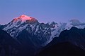 Kinnaur Kailash from Kalpa
 Kinnaur Kailash Resort Kalpa

;)
;)
;)
;)
;)
;)
;)